

Fig. 1: The Delaware Westward Migration
2000
Rees, Mark A., Gina S. Powell, and Neal H. Lopinot. Delaware Town
Archaeological Survey and site assessment in the James River Valley of
Christian County, Missouri, Center for Archaeological Research Report
No. 1081/1109. Click on map to enlarge.
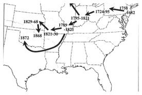
Removal of American Indians living east of the Mississippi River began in the late 1700s. Initially, these removals were voluntary, resulting from treaty negotiations. On September 29, 1817, the Treaty of Maumee Rapids was signed by the U.S. Government, the Delaware, Chippewa, Ottawa, Potawatomi, Seneca, and Shawnee. In this treaty, these six tribes were to relinquish 4,000,000 acres in Ohio for payments and annuities of varying amounts and assigned land allotments. Later that same day, the Ottawa, Seneca, Shawnee, and Wyandot signed the Treaty of St. Mary’s as a supplement to the Treaty of Maumee Rapids. In the Treaty of St. Mary’s, these four tribes received additional monies for the cession of the lands described in the previous treaty and negotiated to own title to the newly acquired lands.

Unit excavation during 2007 Summer Field School at Bell Tavern.
Many treaties were signed at St. Mary’s after 1817, but most important to this area was The Treaty with the Delawares, signed October 3, 1818. In this treaty, also referred to as the Treaty of St. Mary’s, the Delaware ceded all lands in the newly formed State of Indiana (1816) for lands west of the Mississippi and a $4,000 perpetual annuity to be paid in silver. The treaty permitted the Delaware to remain in Indiana for three years to prepare for the move. By 1821, several Delaware leaders and their villages had removed to the James River near its confluence with Wilson Creek. Although the Delaware land grant in southwest Missouri comprised 1,971,200 acres, the Delaware inhabited only 21,120 acres in 1825 and 38,400 acres just prior to their removal.

Opening units during 2007 Summer Field School.
The Osage ceded all but their hunting rights to southwest Missouri in 1808 in the Treaty with the Osage, signed at Fort Clark (now Fort Osage) on the Missouri River. This treaty stated that the U.S. Government would construct a military post to protect white settlers, and would keep a fully-stocked trading post specifically to provide supplies to the Osage in exchange for pelts and furs. The U.S. also promised the Osage a blacksmith, military protection, and a total of $1,200. In exchange, the Osage were to vacate their territories in southwest Missouri except for hunting purposes. However, the treaty stipulated that hunting in any area reserved for other tribes was prohibited. This article of the treaty became a point of contention when the Delaware occupied the James River area. Many conflicts between the Delaware and the Osage are described in letters between Indian Subagent John Campbell and his superior, Major Richard Graham. Some correspondence indicates that the son of Delaware leader William Anderson was killed by the Osage. In 1822, Richard Graham and other signatories dissolved the agreement to sustain the trading post or store at Fort Clark (Fort Osage) for the Osage, and the Osage ceded their lands in Missouri in 1825 for annuities and land in Indian Territory (Oklahoma).
Prior to 1825, Indian removals largely consisted of voluntary emigrations from lands east of the Mississippi River to those west of the big river. As territories became states, the pressure to relocate native peoples increased. As the result of another treaty with the Delaware signed on September 24, 1829, the Delaware on the James River relocated to the modern-day Kansas City area. Euroamerican immigration was already increasing when Missouri became a state in 1821, the same year some Delaware removed to the James River area. During this time, Springfield was becoming a gateway to the west. The intersection of several major transportation routes (the Springfield to Fayetteville Road, the Old White River Road, and the Springfield to St. Louis Road) made the James River even more attractive for agricultural and business pursuits.
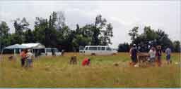
Field school of 2007.
In 1829, President Andrew Jackson established the Indian Removal policy. This policy advocated voluntary removal of native peoples to Indian Territory. In 1830, Congress passed the Indian Removal Act. Most Native Americans did not want to move from their homelands, but some agreed to relocate. In 1835, a small, unauthorized faction of Cherokee signed a treaty with the U.S. in New Echota, Georgia. The Treaty of New Echota was ratified by Congress in 1836, and ceded all of Cherokee lands east of the Mississippi to the U.S. in exchange for $5,000,000 and lands in eastern Oklahoma. Fifteen thousand Cherokee opposed the treaty by signing a petition, but were unable to sway the decision through the Supreme Court. The Treaty of New Echota gave the Cherokee two years to remove themselves voluntarily. Voluntary removal began in 1837, though only a small group of Cherokee participated. Thereafter, Van Buren’s administration initiated forced military removal. By July 1838, more than 13,000 Cherokee were held captive in military stockades. The Cherokee traveled to Indian Territory over both water and land routes, collectively known as the Trail of Tears.
The northern route of the Trail of Tears followed several roads in Greene and Christian counties: the St. Louis to Springfield Road, the Old White River Road, and the Springfield to Fayetteville Road. It has been estimated that 3,000-4,000 Cherokee died during their trek to present-day Oklahoma due to inadequate clothing, hunger, unsanitary living conditions, and the diseases resulting from these unhealthy circumstances. At least 2,000 Cherokee who traversed the northern route camped at the Bell Tavern at the confluence of the James River and Wilson Creek. At least one Cherokee named Dreadful Water died at this place. It is possible that he was buried in Wilson Cemetery very near the Bell Tavern.