
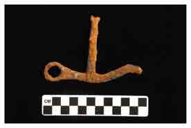
Fig. 1: Iron Snaffle Bit, 23CN1, 2005
Iron, 112.5 mm x 76.9 mm x 10.2 mm, oxidized.
In August of 1861, the area Where the Wilson Meets the James was the scene of military actions before and after the Battle of Wilson’s Creek. On the evening of August 9, 1861, Colonel Franz Sigel stated that he and his troops camped "south of Springfield and near the Yokermill [Forsyth] road." Sigel’s command at that point consisted of the 3rd and 5th Missouri Infantry, commanded by Lieutenant-Colonel Anselm Albert and Charles E. Salomon, and two batteries of artillery, each consisting of 4 pieces, that were under the supervision of Lieutenants Schaefer and Schuetzenbach. Upon receiving an order from General Lyon to move down the Yoakum Mill road and toward the southwest, Sigel was joined by Captains Eugene Carr and Charles E. Farrand, their cavalry troops, and artillery. Sigel’s charge now numbered 1,118 men and six pieces of artillery.
Sigel and his men left camp that evening and headed five miles down the Yoakum Mill Road before turning west. They set up camp in the woods 0.3 miles east of the confluence of Wilson and Terrell creeks and less than one mile north of the confluence of the James River and Wilson Creek. Based on this position, it seems likely that Sigel and his men were actually following the Old White River Road before they headed into the woods. The Old White River Road was located less than three-quarters of a mile northeast of Sigel’s first position the following morning at the outset of the battle. The Yoakum Mill road, believed to be Sigel’s "Yokermill" road, lies further south of his first position and is oriented east-west along the base of a ridge just above the confluence of the James River and Wilson Creek.
The battle was fought and won that day by the Confederate forces. Sigel and his men were routed by the Confederates on the Wire Road near the Sharp’s farm site. They fled down the Wire Road to the Gwin Farm.
According to historians (Bearss 1960; Dosch 1966; Piston and Hatcher 2000) and archaeologist Robert T. Bray (1967), the location of the Guinn/Gwinn/Gwin farm has proved elusive. Lieutenant Colonel Salomon’s 5th Infantry stopped at the Gwin farm while leaving the battlefield via the Wire Road. Dr. R. B. Smith was captured by Salomon at the Gwin farm, but was later released to assist Dr. Melcher on the battlefield. Smith is listed on the 16th Missouri Infantry Roster Company F of the Confederate Army. One-hundred-fifty of the 3rd and 5th infantries and Captain Carr’s cavalry were ambushed at or near the Gwin farm. As a result, a caisson was left behind during the attack. Farrand’s dragoons later recovered the caisson during their march back to Springfield. As such, the Gwin farm was occupied briefly by over 500 soldiers and was the site of an ambush. Maps by Captain Hoelcke (1865), an Aide—de—camp of the U.S. Army, and Sigel (n.d.), offer scant and sometimes conflicting evidence for its location. Bray’s archaeological field research in the mid-1960s did not confirm the location of the Guinn/Gwinn/Gwin farm.
There have been many spellings of the Gwin surname: Guinn, Guin, Gwin, and Gwynne. Several families with some of these surnames lived in Greene and Christian counties during the 1860s. Based on marriage records, land patents, and the 1876 Agricultural Census, it appears that the family who witnessed Sigel’s skirmish spelled their last name GWIN. The following census data places the family in Lincoln Township in 1876:
Gwin, A. J. w[hite] f[emale] 21 — 45 1876 Agri CCM
Lincoln—038—02
Gwin, C. C. w f 21 — 45 1876 Agri CCM Lincoln—037—38
Gwin, H. C. w f 21 — 45 1876 Agri CCM Lincoln—038—03
Gwin, Jack w m[ale] 21 — 45 1876 Agri CCM Lincoln—045—10
Gwin, John w m under 10 1876 Agri CCM Lincoln—045—12
Gwin, M. R. w f under 10 1876 Agri CCM Lincoln—038—01
Gwin, M. V. w f 10 — 18 1876 Agri CCM Lincoln—037—40
Gwin, Robert w m 21 — 45 1876 Agri CCM Lincoln—037—39
Gwin, Sarah w f 21 — 45 1876 Agri CCM Lincoln—045-11
According to a letter written by Joseph Darr, Provost Marshal General of Gratiot Street Military Prison in St. Louis, Mary A. Gwin was arrested in Greene County during the Civil War and was transferred to the Gratiot Street Military Prison in St. Louis from the Myrtle Street Prison in 1864. The date of her arrest is unknown. The Gratiot Street Military Prison and the Myrtle Street Prison were Union prisons that housed men, women, and children having or suspected of having Confederate loyalties. Although in separate physical locations both prisons were under Darr’s administration. J. R. Gwin died on June 20, 1863, and was buried in the Jefferson Barracks National Cemetery in St. Louis. Whether J. R. Gwin is a family member is not known at this time.

Metal detecting for ammunition along White River Road looking for evidence of Sigel's retreat.
The 2007 MSU Archaeological Field School performed a formal investigation of an area north of Terrell Creek along the Wire Road believed to be the location of the Gwin Farm. Students performed a metal detection survey, systematic shovel testing, and formal excavation of nine test units to locate and identify cultural materials. Although no funding was available to analyze the materials, initial examination of the cultural inventory indicates that materials consistent with an 1850s-1860s farmstead were present at the site. No confirmed features were noted, with the exception of the Wire Road, which bisects the site. No house foundations were identified, but the site is located on a highly exposed hilltop that has been subject to agricultural activities for many years.
After the Gwin farm skirmish, Sigel and Carr’s troops were ambushed by Confederate forces hidden in the forested areas along the James River. In his account of the day’s events, Sigel states that they "reached the ford at James Fork of the White River." Captain Otto Lademann, under Sigel’s command during the retreat, stated, "Our little Sigel column was joined by Capt. Eugene Carr’s company of Cavalry, and just as soon as we had crossed Wilson’s Creek at the mouth of Tyrrell’s Creek, the whole of that Confederate cavalry which we had failed to destroy, pounced upon us from flank and rear."
Edwin C. Bearss (1975:96), former Wilson’s Creek National Battlefield historian, and Piston and Hatcher (2000:259) indicate that Sigel’s men took a road heading east after traveling about a mile and a half south-southwestward from where the Wire Road crossed Terrell Creek at Moody’s Spring. Piston and Hatcher (2000:373) also note that "neither the name nor the precise location of the road onto which Sigel’s column turned is known.” Bearss (1975:96) suggests that Sigel and Carr crossed the James River after turning east off the Wire Road, whereas Piston and Hatcher (2000:261) suggest that they crossed Wilson Creek "near its junction with the James River."
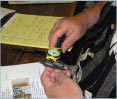
Doug Seneker analyzes artifacts associated with Battle of Wilson's Creek.
CAR archaeologists Jones and Lopinot have researched the locations of the early roads in Greene and Christian counties in order to establish the northern route of the Trail of Tears. Jones and Lopinot have suggested that Sigel’s detachment left the Gwin farm headed south/southwest on the Wire Road, and likely crossed the James River at the location of the former Delaware Town Bridge. After crossing the James River from the west, Sigel’s troops would have taken the Old White River Road/Springfield—to—Fayetteville Road back to Springfield.

Shovel test at 23CN1.
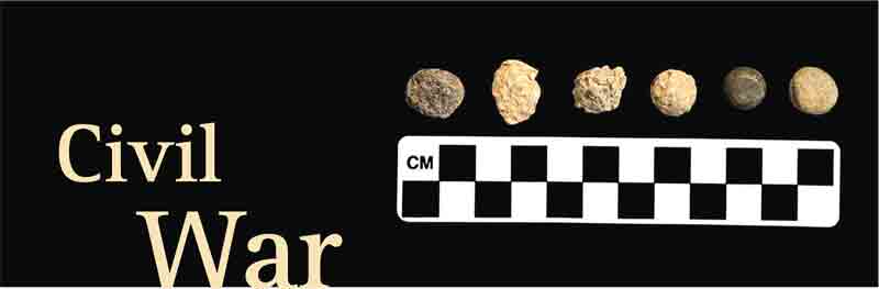
In 2007, Jones tested this hypothesis at two sites (23CN1 and 23CN834) across from the former Delaware Town Bridge. Students from the 2007 MSU Archaeological field school performed intensive metal detection and shovel testing from the east bank of the river to the base of the bluffs, including the Old White River road bed. A number of civil war materials, particularly munitions, were found at both sites. Patterning in the distribution of the materials indicates that Sigel’s troops fled up the bluff line at 23CN834 toward the northeast. Doug Seneker, a member of the Missouri Archaeological Society and recipient of the 2006 poster award for identification of Civil War era artifacts, analyzed the munitions and other metals found in 2007. Seneker identified materials associated with both Confederate and Union troops, which would be expected of such an ambush.